Good morning, Beirut! It’s still pretty messy, but it’s getting there!
Good morning, Beirut! It’s still pretty messy, but it’s getting there!
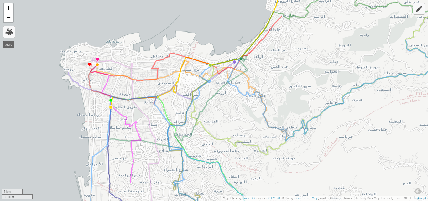
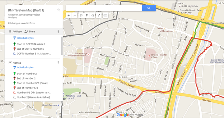
Here’s a sneak preview of our first, ten, mapped bus routes!
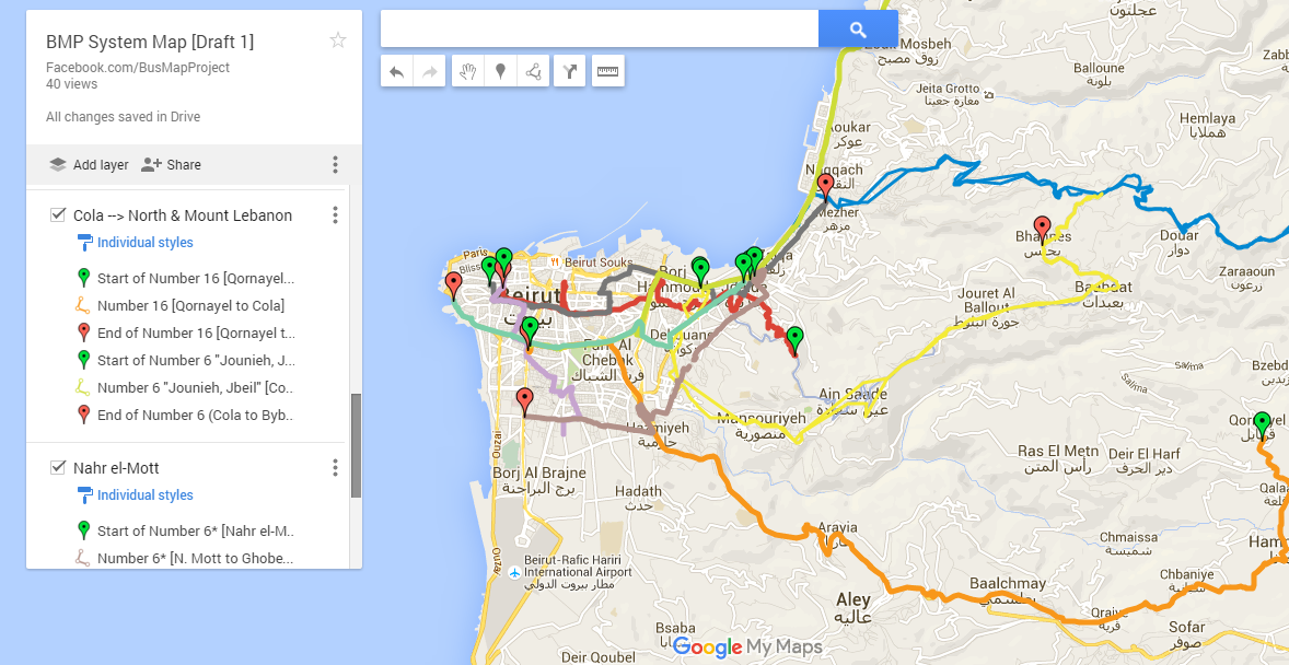
We tracked these using LiveTrekker and Gaia GPS, and dumped them raw onto Google Maps. The routes will need to be cleaned up and labelled (and there’s a lot more coming!) but it’s fun to see the system start to take (some) shape and make (more) sense.
Live outside of Beirut? Want to help us track more bus routes? Yalla!
At times, when people hear our call for ‘taking the existing system seriously,’ they rush to insist that “it is not a ‘proper’ system.” This sort of response seems to imply that we are somehow ‘letting down the cause’ of urban improvement by even referring to it as ‘a system.’
When we say “let’s work with what we have,” some may think that we celebrate the bus system without any criticism, qualification or complaint. When we say “let’s make the system more legible and accessible,” some may worry that we are abandoning any demand or vision of change. We hope that, in time, we can demonstrate that this is not the case.
We believe that no analysis of the transit system can be adequate when made from outside the system. Impressions gathered from the sidewalk, or from being stuck in a car behind a bus, or from second-hand stories and public lore, can be useful to a certain extent. Yet only the lived experience of regular ridership can truly form reliable ideas about the system, and the people and places that constitute it. Sometimes, positive ideas are formed that challenge our prejudices, as car drivers, or as people who only ride ‘proper’ buses in other countries. Other times, we are faced with the full truth of the inequalities that keep the bus system running, like in this article from المنشور
Mapping is a tool for making this system more visible, and hence, more inviting for diverse groups to take part in its formation. It’s a modest proposal, but it is also one small but necessary step towards collective change.
Thank you Green Line for inviting us to discuss our tiny project at yesterday’s “Local Governance of the Transport Sector: Roles & Responsibilities” event. It was great having such a wide range of actors and stakeholders in the same room, and we hope to see this pluralism strengthened and expanded in the future.
As was clear from the rich debates we heard throughout the day, different perspectives will not always see eye to eye. What we think about transportation is determined by what we believe about government, economy, society, etc. We all know that. But even if we agree on the broad slogans, the difficult questions of strategy, method and approach will remain.
As Bus Map Project, we spoke from the perspective of bus riders. While we do not claim to represent anyone other than ourselves, our thinking — as summarized in this slide — is founded on a simple belief: public transport can improve when the riding public begins to speak as riders. This can happen in so many ways: when ridership expands, or when the sector enters the public eye like electricity or waste management has done, or through the relationships we form in the process of collective mapping, etc. But at its most basic level, this begins in the simple act of insisting that *we exist* . . .
That is the core message of our project. The map is a tool we put to use.
‘These are the stories of citizens who head to Beirut and its environs for work, every day, from the four corners of the nation, and who return to their home towns and villages in the evening to ‘divide the bread’ of their workday with their families.’
Have a look at this very important article (in Arabic) that first ran in As-Safir Newspaper. The issue of public transport cannot be disconnected from the prohibitive price of rent and housing in Beirut, the over-concentration of jobs in urban centers, and other wider issues of demography.
Areas served by few or infrequent buses — called ‘transit deserts’ — reflect these socioeconomic patterns, and can often make them worse by skewing our choices of where to live and work. The lack of night services on many routes also affects people’s choices of where to go and who to interact with.
Mapping can help us figure out which regions are under-served by public transport, and in doing so, point to underlying inequalities that can be improved — but not solved — by better network coverage.
How are your day-to-day choices of where to live, who to meet, etc., affected by the transport system? Let us know on our Facebook page.
One of the trickiest aspects of bus travel in Lebanon is figuring out the best and most efficient spots to transfer between different bus routes with little or no walking.
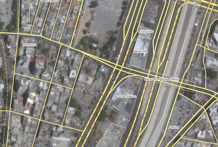
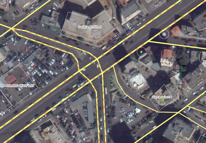
For example, the corner of Armenia Street and Cornich El Naher is a good place to hop off the Number 5 and catch the Number 6 or Number 15 to Cola Roundabout. For the return trip, getting off the Number 15 on Boulevard Sin el-Fil, near Gallery Al-Ittihad, is the best way to catch the Number 2, or get back on the Number 5.
What are your favorite tips and tricks for multi-stage bus travel?
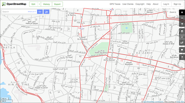
Did you know that OpenStreetMap has a “Transport” layer for Lebanon? And that people have been adding bus routes to it by hand?
One prolific mapper told us about his motivations and experience:
“I moved to Lebanon in 2012. We did not intially have a car so we relied on public transportation. It was a bit frustrating at first because we did not know where the buses went etc. We eventually found the Zawarib book which has a Bus Map in the back. Unfortunately, the bus map only shows “areas” the buses goes to, which made it very difficult to know what street to go to catch a bus. Many times we waited on a street for a bus only to find out the bus actually goes down a parallel street. Or the apparent crossing of 3 routes in one place, but in reality 2 busses cross in one spot, and 2 others cross elsewhere.
When I first discovered OSM in February 2014, I saw the transport layer had a good portion of routes tagged, but mostly on the West side of Beirut down to the airport and only LCC routes. I had become familiar with more of the east side routes, so I added them. Mostly 2, 7, 8, some OCFTC, Sakr. I can’t remember if I’ve tagged any of 9 or 15. I was quite glad to find OSM and added the routes (or partial routes) I knew. I joined OSM primarily so that I could have a good bus route map to reference that showed routes on actual streets. I am not using GPS, but just my memory from when I rode the bus routes.
In mapping the bus routes I discovered that several roads were incorrectly labeled, routed, etc. So in order to put in the bus routes I had to add roads, correct one-way roads, even put in new intersections and roundabouts that were incorrect.”
Initiatives like OSM, Zawarib and onlinelebanonbuses.com need constant maintenance to keep routes updated. Any grassroots mappers out there who can help?
We are big fans of the فان رقم 4 Facebook page. With humor and one or two selfies, this page is humanizing a vital transport link between our capital’s centre and periphery.
According to the admins, the idea for the page began when one of them wondered why people check-in at Verdun or Gemmeyzeh, but not on the van. When we asked them what’s so special about Van 4 as a ‘place,’ they said: “it helps a lot of university students and employees. This is the main community on fb. The line passes through a lot of universities. Downtown. And Hamra. And maybe the bus drivers are special themselves. They’ve got character.”
If mapping is about increasing familiarity, then it needs more than lines drawn on a 2D surface.
In this spirit, learn more about the “ra’m arb’a” in this lovely piece over at Mashallah News:
“Going along for the whole ride exposes an intriguing “slice” of the city. At some points, it flashes past like a fast-forwarding reel of film: blurry and inexhaustible in its contrasting, contradictory impressions. […] At other times, bogged down in yet another traffic jam along Spears Street or at the Mar Mikhael Church intersection, the city lies motionless around you like a massive, panting beast. You finally have time to take a closer look at your surroundings. Maybe you can pick up again, if only for a fleeting moment, the fragile thread that ties all of these disparate places together into one city: Dahiyeh, Ain el Remmaneh, Chiah, Badaro, Ras el Naba`, Basta, Bachoura, Monot, Downtown, Hamra.”
For more poetic takes on the cultural side of transportation, see the full series here.
“Try to locate any place in the Lebanese capital and this, typically, is what you will hear: details and places, not the names of streets or their numbers. Whether visiting a friend for the first time or trying to find someone’s office, the best bet is always to find landmarks, not official addresses – they may exist, but probably won’t be of much help anyway, because no one really uses them.”
The same logic applies along Lebanon’s bus routes; informal ‘stops’ and ‘stations’ have developed near particular buildings, bridges and intersections.
Do you know Al-Ittihad? El-Hayek? Kuwaiti Embassy? Gallery Semaan?