BRT & Integration

This is a follow-up to the previous post, titled ‘BRT & Inclusion’.

As you can see from these slides, the BRT project consists of:

  • Three BRT routes, including two loops within Beirut and its outskirts, and one northbound axis terminating in Tabarja (N.B. the bus service is supposed to keep going until Tripoli, but this would happen in mixed traffic, i.e. without a dedicated lane).
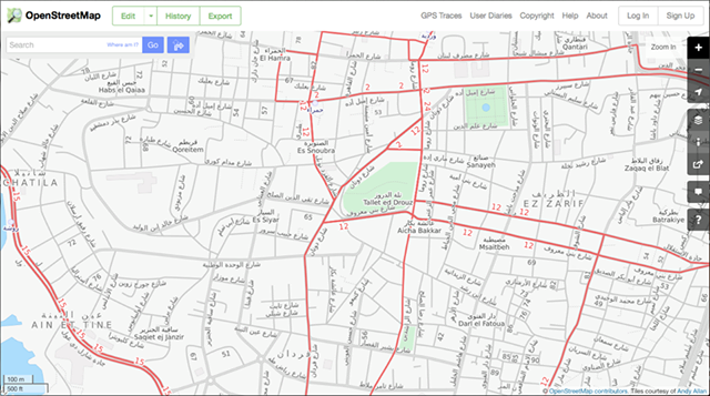
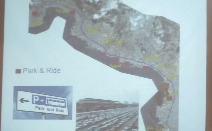
  • For the northbound route, the dedicated lane will occupy the center divider of the highway, necessitating the building of pedestrian bridges connecting each side of the highway to 28 bus stations separated by 850m. The specifications of the two circular routes are still being studied, segment-by-segment, but from comments made in the Q&A session, these routes will most likely use the right side of the road (i.e. take up parking space), with around 23 stops separated by ~500m.
  • Eight park-and-ride facilities, on land already owned by the OCFTC, in areas like Dora, Antelias, Nahr el-Kalb, etc. These would allow people to park their cars and hop on the BRT, hopefully reducing the amount of cars entering Beirut from the north.

Some experts and activists will justifiably want to follow up on every single one of these details, but we’ll keep our eyes on the bigger picture for now (but not too big; this project will certainly not solve the problem of the over-centralization of jobs and services in Beirut, as one audience member complained on Thursday):

These three axes are expected to fit into the existing bus system, and to integrate additional routes that the Ministry of Public Works and Transport is also planning. The same park-and-ride facilities could potentially also be used for the revitalized railway project that is also part of the MoPTW’s master plan.

More broadly, the northern axis could — in theory — motivate the OCFTC and the private sector (and maybe even some enterprising municipalities) to invest in feeder links that connect suburban towns and villages to the coast. Clone this project in other regions, and car-dependency could drop dramatically over time. By creating new flows and interconnections, who knows — maybe even the problem of over-concentration will be lessened over time, as new markets are created in better connected regions.

By finally tackling the problem that most people complain about on the road (i.e. traffic congestion), the state would be in turn liberating the pro-transit lobby from a forced obsession with road safety and air pollution. Hence, another effect of this project could be to shift NGO priorities to more specific improvements, like advocating for rural transport, night buses, nationwide cycle infrastructure, etc. The BRT system could also draw attention to problems we all know exist, but which are kept out of sight, out of mind: if prices are affordable, there may be more mixing of social classes and nationalities in our highly-segregated city, forcing latent tensions into the open, and creating more sites of intervention for rights-based advocates.

Keeping this bigger picture in mind does not mean that we can afford to engage in fanciful, blue-sky thinking, however. The only way we can get to the bright and dynamic future described above, with all its opportunities and challenges, is to get a viable system built, and the only way to do that is to do the hard work of getting more people to talk to each other more often.

Spoiler alert: this is a political process.

At one point during Thursday’s session, a presenter assured the audience that this theoretical system-wide integration isn’t a complicated issue: “nothing is unsolvable” (ma fi shi ma byen7al), he said. This is certainly something we believe as well — if we didn’t believe that, we wouldn’t be here, doing what we’re doing. But it would be naive to think that integration would happen by itself.

Participatory systems are only as effective as their mechanisms of reconciliation — in other words, there’s no use listening to a variety of views if there’s no means of fitting them together in a coherent and broadly-satisfying way. This is especially imperative for infrastructural projects which are inherently meant to meet a wide range of needs. As we often find out too late in the game, nothing is purely technical, and all infrastructures “are inevitably imbued with biased struggles for social, economic, ecological and political power to benefit from connecting to (more or less) distant times and places” (Graham and Marvin, 2002: 11). That quote’s a mouthful, but it’s the reason why engineering can’t be simply left to the engineers.

With regards to public transport in Lebanon, we know from research that many existing stakeholders in the sector want the state to return to its role as regulator, but there is a lack of trust between them, and little confidence in the state’s ability to play this part. One researcher has described this situation in the following terms:

“Although [operators] prefer more regulation and order under transit reform on one hand, they are also apprehensive of their future roles, on the other hand. Placing blame on each other also suggests a “prisoners dilemma” scenario in which each stakeholder operates individualistically, lacking the reassurance to cooperate in a mutually beneficial system.” (Aoun, 2011: 8)

From what we heard on Thursday, it appears that the proposed BRT system has the potential for becoming a catalyst of such a “mutually beneficial system.” The design is supposed to leave enough space for other operators and modes — since there seems to be a (technical) way, all we need to wait for now is the (political) will.

Access to Education: A Question of Mobility?

“Given our very bad infrastructure and transportation situation, no one can underestimate the inconvenience it causes for students that need to travel long distances to reach the university. Everyone is probably wondering what it is like to be a regular university student at the Faculty of Information located in Jdeideh, where few transportation options are available. No busing service is provided for the area; one must either travel by taxi or use one’s own vehicle. Moreover, only the faculty staff members are allowed to park their cars in the university parking. All students and visitors are forced to park in a paid private parking.”

This quote is taken from an article on Hayda Lebnan, written by the Media Association for Peace. It raises an important problem that many students face: getting into university is often half the battle, since after being accepted, getting to your class is still a headache.

Centralization, housing, infrastructure, traffic — it’s very important that people make these connections, because these issues are often addressed separately, though they intersect and amplify each other.

Interestingly, the neighborhood in question — Jdeideh/Sed El Baouchrieh — is one of the better connected areas around Beirut in terms of bus lines, due to its proximity to Dora. Could some of the burden on students be lifted if existing transit options are promoted?

Are you a university student who uses public transport? What routes do you rely on? What challenges do you face?

Stubbornly Modest

One of our favorite things to do is meeting with people who are curious about our project; not only do we get a chance to dive into topics we don’t always post about, but through these discussions, we are also reminded of the importance of issues we’ve become accustomed to as bus riders.

In one such conversation yesterday, we recalled why we’re so insistent on following the grain of the public transport system in Lebanon as it already exists: at the heart of this ‘ethos’ is the simple recognition of the fact that even though reforms are needed, reformers are not always necessary. For all its faults and challenges, the existing system — as a network of service providers and service receivers — already has the seeds of renewal within it. If we want to really notice them within the “chaos,” we should be stubbornly modest in our approach to the sector.

Number 5/8 Bus Notice (Dec 2016)

Here we see the return of a sign that showed up on a few buses two years ago, when bus tickets were first introduced on the Number 5/8. The language is different this time, but the point is the same: the bus route has organically developed its own regulations (“take a ticket and keep it with you,” “payment is upon entry,”, etc.), with no activist campaign or legal reform or ministerial edict imposed from above.

An earlier notice on the Number 5/8 bus

Perhaps this kind of service standardization is too small to make a big deal about, but when we realize what a sign like this means, we start to notice other self-organized features that are worth celebrating:>/p>

Who convinced bus owners that children ought to ride for free? Who forced the young to give up their seats for the not-as-young? Who figured out the emergency protocols for what to do when a series of delays causes one driver to abandon his trip halfway so he can make it in time for his second job as a school bus operator?

We have big dreams for our city, like so many of you out there, but because we dream big, we insist on keeping our eyes and ears open, so that the size of our hearts can match up with our dreaming.

What Buses?

It’s interesting to think about the gap between how little information about the bus system is known in certain circles in Lebanon, and how popular it actually is. In fact, some routes are currently “too popular,” with ridership surpassing capacity, leading to overcrowding as seen in this photo below.

Packed Bus (Nov 2015)

This raises questions of safety, passenger rights, and operator responsibilities. It also points to a very basic paradox: why is this system so invisible to so many people in Beirut? We constantly hear surprise when we discuss our project; too many people simply have no clue that any system of mass transit exists. Why is that?

And what would it mean for the communities who rely of these networks if those of us who dream of more sustainable urbanisms engaged more directly with this actually-existing bus system?

What System?

At times, when people hear our call for ‘taking the existing system seriously,’ they rush to insist that “it is not a ‘proper’ system.” This sort of response seems to imply that we are somehow ‘letting down the cause’ of urban improvement by even referring to it as ‘a system.’

When we say “let’s work with what we have,” some may think that we celebrate the bus system without any criticism, qualification or complaint. When we say “let’s make the system more legible and accessible,” some may worry that we are abandoning any demand or vision of change. We hope that, in time, we can demonstrate that this is not the case.

We believe that no analysis of the transit system can be adequate when made from outside the system. Impressions gathered from the sidewalk, or from being stuck in a car behind a bus, or from second-hand stories and public lore, can be useful to a certain extent. Yet only the lived experience of regular ridership can truly form reliable ideas about the system, and the people and places that constitute it. Sometimes, positive ideas are formed that challenge our prejudices, as car drivers, or as people who only ride ‘proper’ buses in other countries. Other times, we are faced with the full truth of the inequalities that keep the bus system running, like in this article from المنشور

Mapping is a tool for making this system more visible, and hence, more inviting for diverse groups to take part in its formation. It’s a modest proposal, but it is also one small but necessary step towards collective change.

FYI : How Do I Transfer Between Buses..? Looking For Intersections

One of the trickiest aspects of bus travel in Lebanon is figuring out the best and most efficient spots to transfer between different bus routes with little or no walking.

intersections1

For example, the corner of Armenia Street and Cornich El Naher is a good place to hop off the Number 5 and catch the Number 6 or Number 15 to Cola Roundabout. For the return trip, getting off the Number 15 on Boulevard Sin el-Fil, near Gallery Al-Ittihad, is the best way to catch the Number 2, or get back on the Number 5.

intersections2

What are your favorite tips and tricks for multi-stage bus travel?

OpenStreetMap as Model & Ethos

Did you know that OpenStreetMap has a “Transport” layer for Lebanon? And that people have been adding bus routes to it by hand?
One prolific mapper told us about his motivations and experience:

“I moved to Lebanon in 2012. We did not intially have a car so we relied on public transportation. It was a bit frustrating at first because we did not know where the buses went etc. We eventually found the Zawarib book which has a Bus Map in the back. Unfortunately, the bus map only shows “areas” the buses goes to, which made it very difficult to know what street to go to catch a bus. Many times we waited on a street for a bus only to find out the bus actually goes down a parallel street. Or the apparent crossing of 3 routes in one place, but in reality 2 busses cross in one spot, and 2 others cross elsewhere.

OSM-Transport-Layer

When I first discovered OSM in February 2014, I saw the transport layer had a good portion of routes tagged, but mostly on the West side of Beirut down to the airport and only LCC routes. I had become familiar with more of the east side routes, so I added them. Mostly 2, 7, 8, some OCFTC, Sakr. I can’t remember if I’ve tagged any of 9 or 15. I was quite glad to find OSM and added the routes (or partial routes) I knew. I joined OSM primarily so that I could have a good bus route map to reference that showed routes on actual streets. I am not using GPS, but just my memory from when I rode the bus routes.

In mapping the bus routes I discovered that several roads were incorrectly labeled, routed, etc. So in order to put in the bus routes I had to add roads, correct one-way roads, even put in new intersections and roundabouts that were incorrect.”

Initiatives like OSM, Zawarib and onlinelebanonbuses.com need constant maintenance to keep routes updated. Any grassroots mappers out there who can help?

Van Number 4

We are big fans of the فان رقم 4 Facebook page. With humor and one or two selfies, this page is humanizing a vital transport link between our capital’s centre and periphery.

According to the admins, the idea for the page began when one of them wondered why people check-in at Verdun or Gemmeyzeh, but not on the van. When we asked them what’s so special about Van 4 as a ‘place,’ they said: “it helps a lot of university students and employees. This is the main community on fb. The line passes through a lot of universities. Downtown. And Hamra. And maybe the bus drivers are special themselves. They’ve got character.”

If mapping is about increasing familiarity, then it needs more than lines drawn on a 2D surface.

In this spirit, learn more about the “ra’m arb’a” in this lovely piece over at Mashallah News:

“Going along for the whole ride exposes an intriguing “slice” of the city. At some points, it flashes past like a fast-forwarding reel of film: blurry and inexhaustible in its contrasting, contradictory impressions. […] At other times, bogged down in yet another traffic jam along Spears Street or at the Mar Mikhael Church intersection, the city lies motionless around you like a massive, panting beast. You finally have time to take a closer look at your surroundings. Maybe you can pick up again, if only for a fleeting moment, the fragile thread that ties all of these disparate places together into one city: Dahiyeh, Ain el Remmaneh, Chiah, Badaro, Ras el Naba`, Basta, Bachoura, Monot, Downtown, Hamra.”

For more poetic takes on the cultural side of transportation, see the full series here.

Mapping, Lebanon-style. . .

“Try to locate any place in the Lebanese capital and this, typically, is what you will hear: details and places, not the names of streets or their numbers. Whether visiting a friend for the first time or trying to find someone’s office, the best bet is always to find landmarks, not official addresses – they may exist, but probably won’t be of much help anyway, because no one really uses them.”

The same logic applies along Lebanon’s bus routes; informal ‘stops’ and ‘stations’ have developed near particular buildings, bridges and intersections.

Do you know Al-Ittihad? El-Hayek? Kuwaiti Embassy? Gallery Semaan?